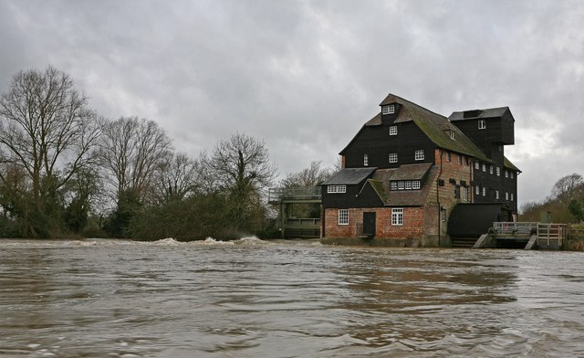
At least one London tube station has been submerged in water, while other parts of the country are under a yellow warning for thunderstorms, with poor conditions expected to continue into the weekend.
Floods are one of the UK’s most pressing climate problems, with a warming planet leading to more frequent and intense flood events, as well as contributing to sea level rise.
Around 5.2 million properties are at risk across the country, a number that could double without more action to protect homes.
Earlier this year, the Environment Agency even cautioned that some coastal communities will have to relocate due to sea level rise and coastal floods making some areas uninhabitable.
This might all sound scary, but being prepared is the best way to shield yourself from the potential impact.
Advertising helps fund Big Issue’s mission to end poverty
Advertising helps fund Big Issue’s mission to end poverty
Here’s everything you need to know about checking whether you’re at risk, and what help you might be entitled to.
How can I find out if my home is at risk of flooding?
To use it, type in your postcode and the map will show you which areas near your house are at risk from flood events.
The flood risk is divided into bands of varying severity, ranging from “high”, a greater than one in 30 chance of flooding in a year, to “very low” – a one in 1,000 chance in a year.
Parallel’s map takes into account local flood defences.
Advertising helps fund Big Issue’s mission to end poverty
Aside from this map, a free government tool can also show you the long-term flood risk for a local area.
This tool gives you a summary of the main flood drivers in your area, a summary of your risk level and who is responsible for managing floods where you are.
The Scottish Environmental Protection Agency (SEPA) offers a map for Scotland showing which areas are most at risk.
All these tools show current risk, rather than potential future risk as a result of climate change.
For a better idea of the impact of floods on your area in the future, Climate Central’s flood map shows projections for between 2030 and 2100.
Which parts of the country are most at risk of flooding?
According to a recent report from LV and Localis, 12 local authorities in England have more than 10 per cent of homes in areas at high risk of flooding. These are:
Advertising helps fund Big Issue’s mission to end poverty
South Holland
Boston
Fenland
Runnymede
King’s Lynn & West Norfolk
Kingston-upon Hull
East Lindsey
North Lincolnshire
Spelthorne
Doncaster
Exeter
Windsor & Maidenhead
This list only reflects areas with a high percentage of homes in at-risk areas, rather than areas with the highest level of flood events generally.
Why is housing still being approved in high-risk areas?
The twin pressures of the climate crisis and the housing crisis mean more land is becoming prone to floods at the same time as housing need is intensifying.
In local authorities with existing risk levels for flood events, this means that there’s sometimes little choice over where to build desperately-needed homes.
This leads to homes being built on floodplains in spite of national planning policy directing local authorities to avoid this wherever possible.
In November, think tank Localis found that almost 200 planning applications had been approved in 2021 to build a total of 5,283 homes on floodplains in the highest-risk local authorities in England.
What protections are in place – and what help can I get?
In 2021, the government outlined an investment of £5.2billion into flood protection for the UK, with plans for more than 1,000 schemes to be implemented in 2021 and 2022.
Advertising helps fund Big Issue’s mission to end poverty
Further measures have since been announced by the Environment Agency, including a fresh national assessment of flood risk and new long-term investment scenarios.
If you’d like to find out more about what flood protections are in place in your area, you can contact your local authority to find out.
In terms of protecting your own home, a number of property owners can access the Flood Re scheme, which helps make insurance affordable for those vulnerable to floods.
You can use the Flood Re tool on its website to find out whether you’d be eligible for help.
You may also be able to access grants and funding in order to future-proof your property or business. You can find out more about these grants on the flood guidance website.
Will you sign Big Issue's petition to ask Keir Starmer to pass a Poverty Zero law? It's time to hold government to account on poverty once and for all.
Strike dates 2023: From train drivers to NHS doctors, here are the dates to know
Support our vendors with a subscription
For each subscription to the magazine, we’ll provide a vendor with a reusable water bottle, making it easier for them to access cold water on hot days.